Groundwater is water that occurs below the Earth’s surface at depths where all the pore (open) spaces in the soil, sediment, or rock are completely filled with water (see Figure 1). All groundwater, whether from a shallow well or a deep well , originates and is replenished (recharged) by precipitation. Groundwater is part of the hydrologic cycle, originating when part of the precipitation that falls on the Earth’s surface sinks (infiltrates) through the soil and percolates (seeps) downward to become groundwater. Groundwater will eventually come back to the surface, discharging to streams, springs, lakes, or the oceans, to complete the hydrologic cycle.


A well that is drilled will first pass through a zone called the unsaturated (vadose) zone where the openings in the soil, sediment, or rock are primarily filled with air (Figure 1). Water exists here only in transit downward. The thickness of this zone depends on such factors as climate, elevation, season of the year, and area-wide groundwater withdrawals through pumping. In the rainy season of humid areas, the unsaturated zone may be a fairly thin layer, extending from the land surface to only a few meters (10 feet or so) below the surface. But in drier months of the year, the unsaturated zone may extend deeper as recharge to the aquifer declines and withdrawals increase. In arid regions, the unsaturated zone may be a thick layer, extending from the land surface to 300 meters (1,000 feet) or more below it.
Further drilling will reach a zone called the saturated zone where all of the openings are filled with water, and where the water is known as groundwater. If the saturated zone is permeable enough to supply a well with water under normal hydraulic gradients, this saturated zone is called an aquifer. Importantly, an aquifer is not an underground river, lake, or pool. Rather it consists of geologic materials whose open spaces (pore spaces) are filled with water that moves down a pressure gradient, and which can be tapped productively by wells. The top of the saturated zone is called either the water table (if the aquifer is unconfined) or the potentiometric surface (if the aquifer is confined): see Figure 2.
To visualize the zones, imagine a bucket filled with gravel. Ample pore space exists between the individual pieces of gravel. If water is poured on top of the gravel, the water will percolate down through the pore spaces and begin to fill these spaces from the bottom up. The water in pore spaces at the bottom of the bucket represents groundwater; that is, all the pore spaces are filled with water. If holes were punched in the bottom of the bucket, water would flow out. Using this analogy, the bucket of gravel is like an aquifer: water is stored within in it and will move through it toward a discharge point—in this case, the hole in the bucket.
Permeability is determined by the size of pores and the degree to which they are interconnected, and hence, the ease by which water can flow through the material. Highly permeable aquifers, such as those comprised primarily of coarse sand and gravel, can supply more water than less permeable aquifers, such as those comprised of silts or clays. In this example, the pores in sand and gravel are larger than those in silt and clay, so water moves through sand and gravel more quickly. In some aquifers, especially in sedimentary bedrock, water occurs in fractures (cracks) instead of pore spaces in sediments. The yield from a fractured rock aquifer can vary from less than 1 liter per minute, or about 0.3 gallons per minute (if the well encounters few fractures) to large quantities of groundwater—for example, more than 300 liters per minute, or about 100 gallons per minute (if the fractures are numerous and large).
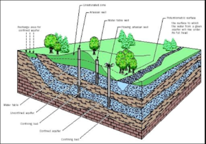
Figure 2. AQUIFERS. The water table defines the top of an unconfined aquifer. Water in a well penetrating an unconfined aquifer will remain at the elevation of the water table. Some streams and lakes intercept the water table, allowing direct groundwater–surface water exchange. The potentiometric surface reflects the water pressure of a confined aquifer, and is the level to which water in a well will naturally rise (i.e., to an elevation above the confined aquifer it penetrates). WELLS. All wells in confined aquifers are considered artesian wells. If the elevation of the potentiometric surface is above than the elevation of the land surface, groundwater will flow naturally (without pumping) from the well, known as a flowing artesian well. RECHARGE. Recharge to unconfined aquifers occurs over a wide area of the unsaturated zone, directly above the aquifer. Recharge to confined aquifers occurs only where there is a pathway (e.g., a fracture) through the confining layers, or where the confined aquifer is exposed at the surface and becomes unconfined. Generally, the recharge area for a confined aquifer is at a higher elevation than the aquifer itself, and may be many kilometers from the well.
Aquifers are divided into two types: unconfined and confined. An unconfined aquifer is often shallow, and the vadose zone above it primarily contains permeable material. The top of the aquifer is the water table. The water table moves up and down on a seasonal basis. It is highest during the wet season owing to higher recharge and lower pumping rates (e.g., no irrigation), and lowest during the dry season because of limited recharge and higher use (e.g., a high rate of irrigation).
Confined aquifers may be shallow or deep, and are characterized by being separated from the surface by low-permeability strata (e.g., geologic layers) that confines the groundwater below it. In a confined aquifer, groundwater is generally under pressure. This water pressure may vary seasonally, similar to the water table in an unconfined aquifer.
Because groundwater in a confined aquifer is under pressure, it will rise in a well bore above the level of the aquifer penetrated by that well. One way to visualize this is to squeeze a milk or juice pouch that is punctured at the top by a straw. If the straw fits firmly into the squeezed pouch, the liquid will rise up into the straw, above its level inside the pouch.
Artesian and flowing artesian wells are typical of wells drilled into confined aquifers. An artesian well is one in which the groundwater rises above the level of the penetrated aquifer. The water in an artesian well will rise to an elevation at which the pressure of the water in the aquifer is matched by the pressure reflected by the elevation of the water in the well; this level is known as the hydrostatic level. If groundwater reaches all the way to the surface under its own pressure, the well is called a flowing artesian well (see Figure 2).
The water table (or the potentiometric surface of a confined aquifer) is not a flat surface: rather, there are high areas and low areas just like the hills and valleys found on land. Just as surface water tends to flow downhill, groundwater tends to move downgradient from water-table areas (or potentiometric regions) of higher elevation to water-table areas (or potentiometric regions) of lower elevation.
Normally, but not exclusively, the higher water-table areas of uncon-fined aquifers coincide with higher elevation at the land surface, and the lower water-table areas coincide with low areas. As a result, groundwater in unconfined aquifers tends to flow towards, and discharge to, streams, lakes, and wetlands, because these waterbodies often occur in low points of the watershed. Even groundwater from confined aquifers tends to discharge to larger area-wide rivers.
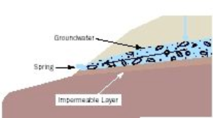
Two other common discharge areas for groundwater are springs and wells. A spring is an area where groundwater has access to the land surface. In some cases, precipitation infiltrating downward from the ground surface encounters a relatively impermeable rock or sediment layer as it moves down toward the underlying aquifer. The groundwater, which cannot pass through the low-permeability layer, moves along the top of the layer until the layer is exposed at the ground surface and the water can emerge as a spring. In this typical “gravity spring,” the most common form of spring, gravity is the driving force for water movement. Such springs commonly occur at the side of a hill, or at an outcrop such as a bluff or canyon wall (see the small figure below). In other cases, fractures allow groundwater to move from the aquifer to the surface. Groundwater from a spring can issue onto the land surface, or directly into a stream, lake, or ocean.
A well also provides a connection between groundwater and the land surface. In general, a pump is used to draw the groundwater up to the land surface where it can then be used.
Lorem ipsum dolor sit amet, consectetur adipiscing elit, sed do eiusmod tempor incididunt ut labore et dolore magna aliqua. Ut enim ad minim veniam
When referring to how fast surface water moves, hydrologists generally talk in terms of either meters or feet per second. Groundwater moves much more slowly than water in streams, often at rates of only a few centimeters (inches) per day. Groundwater velocity is controlled by the permeability of the aquifer and steepness of the water table (or potentiometric surface). The more permeable the aquifer and the steeper the the slope of the water table or potentiometric surface (i.e., the pressure gradient), the faster groundwater moves. In highly permeable gravels or in fractures, groundwater may move 10 meters (33 feet) per day or more.
Recharge, or replenishment, of an unconfined aquifer occurs at the ground surface directly above the aquifer. In contrast, recharge to a confined aquifer may occur many miles away, typically at a higher elevation where the aquifer is no longer confined; that is, where the overlying materials are permeable and allow percolating rainfall to reach the confined aquifer (See “Recharge to Confined Aquifer” in Figure 2). Once recharged, the groundwater flows downgradient to where the aquifer is confined.
Wells supply water by being drilled to a depth below the water table of an unconfined aquifer or into a confined aquifer. When a well is pumping, it lowers the water table (or the potentiometric surface) around it. This causes groundwater to move towards the well, supplying the water that is being pumped out of the well. As long as the pump intake is below the water level in the well, water can be pumped.
Well interference occurs when the water table (or potentiometric level) in one well is significantly lowered as a result of the pumping of a nearby well. Sometimes the interference can be so great that the water table (or potentiometric level) in the first well is lowered below the pump intakes or even below the bottom of the well itself.
How can wells interfere with one another? When pumping begins, the water table (or potentiometric surface) around the well begins to drop as the aquifer supplies water to the well. This drop in water levels is called drawdown. The area of drawdown is shaped like a three-dimensional, funnel-shaped cone, centered on the well. Pumping rate and aquifer characteristic determine the depth of the drawdown cone and the areal extent (horizontal) of the drawdown.
The following illustration represents the water table as the top of the lower cube; the aquifer as the lower cube itself; and the well as a pipe extending from the land surface (top of the upper cube) down to the aquifer, below the water table. The drawdown cone, also known as a cone of depression, is indicated.
How deep and how wide the drawdown cone is depends on aquifer characteristics and how much water is being pumped. Interference occurs when the drawdown cone from one well reaches another well and lowers the water level in that well. Consider the following two examples of well interference in a water-table aquifer.
First, suppose a high-capacity irrigation well (Well 1 on page 155) is drilled near two shallow private drinking-water wells (Well 2 and Well 3). High pumping volumes from the irrigation well may lower the water table from its original level to a new (lower) level, which is at a depth below the private wells. In this example, Well 2 would be unable to pump water while the irrigation well (Well 1) is pumping. Well 3 barely penetrates the lowered water table, and would likely experience intermittent pumping failures if the irrigation well were also pumping. In other words, the irrigation well pumpage interferes with the water production from both Well 2 and Well 3.
As another example, suppose a city wants to increase its water supply. A new well (Well B below) is drilled very close to an existing well (Well A) that is highly productive. When both wells are pumping, they mutually interfere with one another, and the production of both wells is lowered. Because of this mutual interference, the combined production of the two wells may be only slightly greater than the production of each well by itself.
In the diagram below, the drawdown associated with Well A by itself is shown as a heavy dashed line. Well B pumping by itself would produce a similar drawdown around itself. Note that the amount of water available to Well A (from the bottom of the cone to the bottom of the well) has been substantially reduced by the placement of Well B too close to Well A. Neither Well A or Well B can now produce as much as if they were pumping by themselves.
In most states, laws prohibit significant well interference. A well cannot be operated in such a manner to significantly reduce the production from previously existing wells. The potential of well interference can be calculated if hydrologists know the permeability, thickness and storage characteristics of the aquifer and at what rate the well(s) in question will be pumping.
Excessive pumping of water from an aquifer may result in an areawide lowering of the water table. This will eventually occur anywhere more water is pumped than is recharged by infiltrating precipitation. Overdrafting an aquifer can result in changes in groundwater quality, a reduction in groundwater availability (and hence the loss of water supply to current and future wells), and perhaps even a permanent loss of the aquifer’s capacity to store water. Many states use the water right process to manage groundwater quantity and to ensure that overdrafting does not occur.
There is a limit to how much groundwater can be pumped out of an aquifer without causing depletion of the resource. If more groundwater is pumped out than is naturally recharged by precipitation, the amount of water stored in the aquifer will decline. In some areas, pumping has resulted in subsidence (sinking) of the land surface. Similar conditions may arise from the pumping of petroleum.
Groundwater occupies volume in an aquifer by filling pore spaces between the mineral grains. Because water is essentially incompressible, that water helps support the weight of the overlying rock and soil. When the water is pumped out, the pore spaces may collapse under the load and the volume of the rock and soil decreases. In many areas, that pore space is forever lost; that is, water cannot reenter the aquifer.
Significant subsidence as the result of excessive pumping has been recorded in areas such as:
Unlike the subsidence caused by cave-ins that result from the collapse of underground mines, sinkholes caused by dissolution of underground carbonate rocks, or human-made sinkholes caused by broken water mains, subsidence as a result of aquifer overdrafting occurs slowly and over a large area. Residents in the region are unlikely to even notice it.
Bibliography
Heath, R. C. Basic Ground-Water Hydrology. U.S. Geological Survey Water-Supply Paper 2220 (1983).
Todd, David Keith. Groundwater Hydrology, 2nd ed. New York: John Wiley & Sons, 1980.Internet Resources
Drinking Water Program. Groundwater. Portland, OR: Oregon Department of Human Services, 1995. Available online at <http://www.ohd.hr.state.or.us/dwp/gwater.htm> .
Read More: http://www.waterencyclopedia.com/Ge-Hy/Groundwater.html#ixzz4Mo9zYOG1